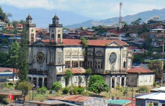
Puriscal is the fourth county of San José province, roughly 43 kilometers southwest of the capital. Its head city is Santiago, usually called Santiago de Puriscal. The county covers 555 square kilometers and sits at a mean elevation of 945 meters; Santiago itself is higher, at about 1,105 meters. San Antonio is one of nine districts here, alongside Santiago, Mercedes Sur, Barbacoas, Grifo Alto, San Rafael, Candelarita, Desamparaditos and Chires.
The name comes from farming. A purisco is the flower of the common bean, and a puriscal is a field of beans in flower.
Before the county
The area was Huetar territory before Spanish contact, falling within the Reino de Pacaca. During the colonial period it was crossed rather than settled: footpaths through the hills became a mule road, and from 1601 that route carried trade toward Panama.
Permanent settlement came late and grew around coffee. The first hermitage was built in 1858 on land donated by Pedro Jiménez Meléndez. The parish, dedicated to Santiago Apóstol, was erected in 1871.
Becoming its own jurisdiction
Puriscal was established by decree on Aug. 7, 1868 as a county — a cantón in Costa Rican usage, the term you will see on land records. Institutions followed over the next several decades: a girls’ school in 1886, a music school funded by residents in 1891, and the Darío Flores Hernández school in 1900. Puriscal received the title of villa in 1915. Piped water arrived by gravity from Mercedes Sur between 1920 and 1923, and public electric lighting was inaugurated on July 25, 1926.
The old temple
The most recognizable building in Santiago is one nobody can enter. The old Templo de Santiago Apóstol, a reinforced-concrete church directed by engineer Jacinto Rodríguez, was built over roughly two decades in the mid-20th century. It sits on a local fault, and cracks appeared as early as the 1950s.
A seismic swarm in 1990 ended its use. The last Mass was held that year, and the building was declared uninhabitable. The Ministry of Health ordered demolition in 2009. In August 2012 the structure was added to Costa Rica’s list of architectural heritage by executive decree, which prohibited its demolition outright. It still stands, fenced and overgrown, and is now being considered for preservation as a protected ruin rather than restoration as a church.
Puriscal today
The local population was about 33,000 at the 2011 census, estimated near 38,500 by 2022. The area remains predominantly rural. Santiago provides the practical services a resident or a project needs: banks, clinics, schools, hardware and agricultural suppliers, and a weekly farmers market.
La Cangreja National Park lies in the Chires district, about 45 kilometers south of Santiago.
Why this matters to a buyer
Three things stand out for anyone evaluating land here.
The elevation band puts Puriscal in the same climate range that makes the Central Valley desirable, without the pricing that follows a well-known name. The distance to San José is short enough for services and the airport to be practical.
The seismic history is real and should be treated seriously. The old temple is a visible reminder that local fault conditions matter, and any development here warrants proper geotechnical work rather than assumptions.
And the area is agricultural rather than resort-driven. That shapes what gets built, who the neighbors are and how the market behaves.
Orchid Point Estates sits in San Antonio de Puriscal. The Land covers the parcel itself: acreage, lot layout, roads, water and power.